
Tsankawi (sank-ah Wee) was built in the 1400's by the Anasazi Pueblo Indians. In the Tewa language the name means,"village between two canyons at the clump of round sharp cacti."
A fellow workshop classmate who lives in Santa Fe recommended visiting this prehistoric site northwest of Santa Fe, considered sacred by many local pueblo people. She described it as magical and recommended going on a weekday when we could experience it without crowds. She said it was an easy hike, though not an easy place to find.
It is located south of the San Idefonso Pueblo and is part of Bandalier National Monument but there are no signs on any of the roads indicating its presence. The site was abandoned by the pueblo people in the 1500's and deteriorated since then. It is undeveloped and unexcavated. From the north when you turn from Rte. 502 onto Rte.4 toward Bandalier, it is less than a quarter mile on your left, just before the stop light at Jemez Rd. There is simply a gravel parking lot to indicate where you should stop. We drove by it and had to do a u-turn beyond the light. There was one other car there but we basically had the place to ourselves. Map
It is located south of the San Idefonso Pueblo and is part of Bandalier National Monument but there are no signs on any of the roads indicating its presence. The site was abandoned by the pueblo people in the 1500's and deteriorated since then. It is undeveloped and unexcavated. From the north when you turn from Rte. 502 onto Rte.4 toward Bandalier, it is less than a quarter mile on your left, just before the stop light at Jemez Rd. There is simply a gravel parking lot to indicate where you should stop. We drove by it and had to do a u-turn beyond the light. There was one other car there but we basically had the place to ourselves. Map
When I was a baby I was a climber. My mom said that before I could walk or even crawl, she would find me perched on bureaus and tables, smiling. I would pull out drawers on anything that had a drawer and proceed to climb to the top of whatever it was. You would think this was the beginning of a future mountain climber, someone likely to conquer Mt Everest... and you would be wrong! I am not sure what happened to that love of climbing but over the years it has disappeared and been replaced by a fear of heights. I am not even crazy about ladders. Going up one is not so bad but stepping off one onto a roof or off from a roof onto a ladder is another thing. I hate it, heart palpatations are likely to occur. This will be important to remember as we move through this adventure. In spite of or perhaps because of my fears, this hike was the highlight of our southwest trip. This indeed is a magical place worthy of a visit if you are in the area. Be sure to bring plenty of water, sunblock and wear a hat.
At the beginning of the trail is a building with a picnic table and a box that has a booklet on the trail for the reasonable price of $1. There are markers on the map that correspond with numbered markers along the trail. Information about the original settlement or notes on what to look for accompany each marker in the booklet. There is also a sign describing the trail- including three ladders and sharp dropoffs- and it requests you to respect the area and leave it as you found it. At the mention of ladders and narrow cliffside trails, anxiety began to set in but I chose to ignore it and move on.
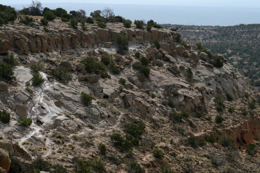
What you see immediately is the tuff rock. Formed of consolidated volcanic ash, this rock is prevalent throughout Bandalier. There are a multitude of natural openings and caves in these rocks and it is no wonder the native people took advantage of the formations to establish their villages. The tuff provided stone blocks for building homes, plus it is very soft, making it possible to carve small rooms (cavats) in the walls of the tuff mesas using tools made of harder stone.

The first ladder appeared but you can easily avoid climbing it if you prefer to take a short alternate trail up to the top. I was loaded down with camera equipment and chose to go around this ladder! That's my story and I am sticking to it!

After exploring the hollowed out rocks continue either way to the top for some wonderful views of the area.

..and a view of the trail to come.
More views to come on the next blog entry! You can click on this photo to better see the trail (white rock) in the left area of this photo. This is the return trail coming down from the mesa.

This is a closer view of the trail- formed by the footprints of the ancient people worn into the soft tuff rock.
No comments:
Post a Comment